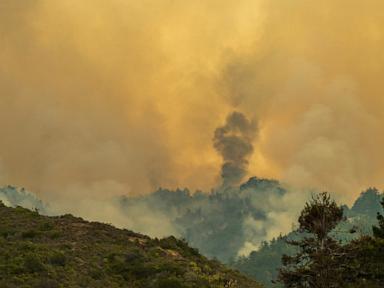
Driving down California's iconic Highway 1 is supposed to be a dream. Right now, it is a logistical nightmare. Two active wildfires—the Timber Fire and the fast-growing Plaskett Fire—have scorched over 50,000 acres of rugged terrain along the Big Sur coast, shutting down massive stretches of America's most famous scenic drive and putting local communities on edge.
If you are planning a trip to the Central Coast or wondering how these blazes are reshaping local life, you need to look past the standard weather alerts. The reality on the ground involves brutal topography, tricky firefighting tactics, and a region that cannot catch a break.
Understanding the Big Sur Twin Fires
Big Sur is gorgeous, but its geography is a firefighter's worst nightmare. U.S. Forest Service public affairs officers often describe the local terrain by saying it looks like an EKG readout. It is steep, vertical, and choked with heavy vegetation that hasn't seen a significant wildfire in over half a century.
This remote landscape is driving two distinct blazes:
- The Timber Fire: Ignited on August 8 in the northern section, this older fire has scorched nearly 25,000 acres. Fire crews have managed to secure around 20 to 22 percent containment, allowing them to start pulling back some equipment and reopening select northern strips of Highway 1 near the Big Sur Valley.
- The Plaskett Fire: Breaking out further south near Plaskett Creek on August 26, this newer fire exploded in size, rapidly overtaking its northern counterpart and torching close to 30,000 acres. With rough terrain and a lack of previous burn history, containment has hovered near zero to one percent for days, keeping mandatory evacuation orders and warnings active across Monterey and San Luis Obispo counties.
Together, these fires have created a pinch point that cuts off travel entirely between Carmel and Cambria.
Why Fighting Fires in Big Sur Is Nearly Impossible
You cannot just drive a fire truck up a 70-degree canyon wall. Direct attack tactics fail when the earth drops off into the Pacific Ocean on one side and shoots straight up into dense brush on the other.
Instead, thousands of firefighters from across the country are relying on a mix of heavy machinery, aviation, and local knowledge. Water-dropping helicopters and air tankers fly constant sorties to cool down active fronts. Meanwhile, ground crews use back-burning operations—deliberately torching brush in controlled pockets—to starve the larger fires before they can race toward populated neighborhoods and local businesses.
Local residents play an unexpected role here too. Long-time homeowners who have survived multiple fire seasons are handing their own hand-drawn maps over to battalion chiefs. These maps point out hidden water wells, private streams, and old logging tracks that official satellite imagery misses. It is a gritty, community-wide defense effort.
What This Means for Travelers and Locals
Visitors love Big Sur for its isolation, but that same isolation makes evacuations stressful and sudden. If you had a late-summer or Labor Day weekend getaway booked down the Central Coast, your itinerary is toast. Caltrans has kept major portions of Highway 1 closed because falling rocks, burned tree roots, and unstable hillsides make driving suicidal even after flames pass.
If you live in the area or own property nearby, the playbook is simple but demanding:
- Keep your fuel tank full: If an evacuation warning flips to an order, you need to move instantly.
- Know your escape routes: Identify paved roads and alternative exits long before smoke clears the horizon.
- Check official sources daily: Ignore random social media panic and stick to Cal Fire and U.S. Forest Service incident pages for actual containment stats.
Wildfire season along the California coast is stretching longer and hitting harder. Until the region gets a soaking, late-season rain, Big Sur remains locked in a battle against the elements. Pack your patience, cancel your coastal driving shortcuts, and give the crews on the ground room to work.